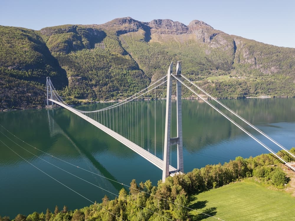
Hardanger Bridge
Hardanger Bridge
At 1,380 meters long and opened in 2013, the Hardanger Bridge spans the Hardangerfjord between Bu and Vallavik. Practical guide to visiting.
The Hardanger Bridge spans the Hardangerfjord between the towns of Bu and Vallavik, in southwestern Norvège. At 1,380 meters in length, it was Norway's longest suspension bridge upon its opening in 2013 and remains one of Europe's largest. Beyond its engineering achievement, it plays a strategic role in connecting the country's east and west, replacing ferries that once plied the crossing.
Why visit the Hardanger Bridge
The structure offers a rare vantage point over the Hardangerfjord, Norvège's second-longest fjord, from a height that commands views of the surrounding waters and mountains. Its design, suspended between two tunnels carved into the rock, illustrates a hallmark of Norvège infrastructure: adapting to challenging terrain to link isolated valleys.
The bridge features a pedestrian and cycling path that runs alongside the roadway, making it possible to cross on foot or by bike rather than by car and to observe the fjord from the bridge deck. It's a natural stop for travelers exploring the region by bike or car, along the route between Oslo and Bergen.
History and construction
The project was approved in 2006 by the Norvège Parliament as part of a modernization plan for the road network connecting the country's east and west. Construction spanned several years, and the bridge opened in 2013, replacing ferries that previously crossed the fjord between Bruravik and Brimnes.
Funding came primarily from tolls paid by users, supplemented by savings from the elimination of the ferry service. The technical specifications are noteworthy: a total length of 1,380 meters, a main span of 1,310 meters between the two towers, and a suspended deck at a height compatible with navigation in the fjord. At its opening, the structure was Norvège's longest suspension bridge and ranked among Europe's largest.
What to see and do
Cross the bridge on foot or by bike
A dedicated pathway separate from motor traffic allows pedestrians and cyclists to traverse the bridge. The crossing takes about twenty minutes on foot and offers sweeping views of the Hardangerfjord below. Be prepared for often strong winds: bring a windproof layer even in summer.
Around the bridge
On the Bu side (south bank), a parking area allows you to stop for photographs and access the pathway. On the Vallavik side (north bank), the bridge connects directly to the Vallavik tunnel, which opens onto Route Rv 13 toward Voss and Ulvik.
Practical information
- Access: free year-round for motor traffic, pedestrians, and cyclists.
- Toll: crossing by car is subject to a fee (automatic system via license plate recognition); free for pedestrians and cyclists.
- Time needed: allow 30 minutes to 1 hour if crossing on foot, longer if you pause to explore the surroundings.
- Equipment: windproof clothing recommended, as the deck is exposed.
When to visit
The bridge is accessible year-round, but the experience varies considerably by season.
- Summer (June to August): the best period for crossing on foot or by bike, with long days and pleasant temperatures. The Hardangerfjord is also most visited during this season.
- Spring and autumn: interesting light and fewer crowds, but cooler and windier conditions.
- Winter: the bridge remains open, but crossing on foot or by bike becomes impractical due to ice and wind.
How to get there
By car
From Kinsarvik (south bank), follow the road toward Bu: the bridge is reached after the Bu tunnel. From Voss (north bank), take Route Rv 13 toward Ulvik, then the Vallavik tunnel, which leads directly to the north end of the bridge.
By public transport
The regional operator Skyss runs bus line 990, which serves Bu and provides access to the bridge without a car from the region's main hubs.
Nearby attractions
- Hardangervidda Nature Centre: an interpretation center dedicated to the wildlife, flora, and geology of the Hardangervidda plateau, about twenty minutes' drive away.
- Mount Molden: a peak offering expansive views over the inner fjords, ideal for a full-day hike.
- Hardangerfjord cruises: several operators offer boat excursions from riverside towns to explore the fjord from the water.
To extend your itinerary, two other major fjords deserve a visit: the Sognefjord, Norvège's longest fjord, and the Geirangerfjord, a UNESCO World Heritage site. A stop at Bergen's fish market rounds out a natural circuit through the country's west.
Frequently asked questions
Frequently asked questions
The Hardanger Bridge fits naturally into a circuit through Norvège's western fjords. To plan your itinerary, explore our Norvège trips.
Interested in this visit?
We can include it in your personalised itinerary.