Lake Kivu
90 km of intricate shoreline at 1,460 m altitude, warm waters free of bilharzia and three gateway towns (Rubavu, Karongi, Rusizi) for a peaceful stop after gorillas or Nyungwe.
Lake Kivu stretches for 90 km from north to south along the border with the Democratic Republic of Congo, at 1,460 m altitude. It is a rift lake, deeper than 480 m in places, with warm waters (23 to 25°C) free of bilharzia and crocodiles, making it one of the rare bodies of water in East Africa where swimming is safe without health precautions. Three main towns mark the Rwandan shore: Rubavu in the north, formerly known as Gisenyi, Karongi in the center (the former Kibuye), and Rusizi in the far south, facing Bukavu in the DRC.
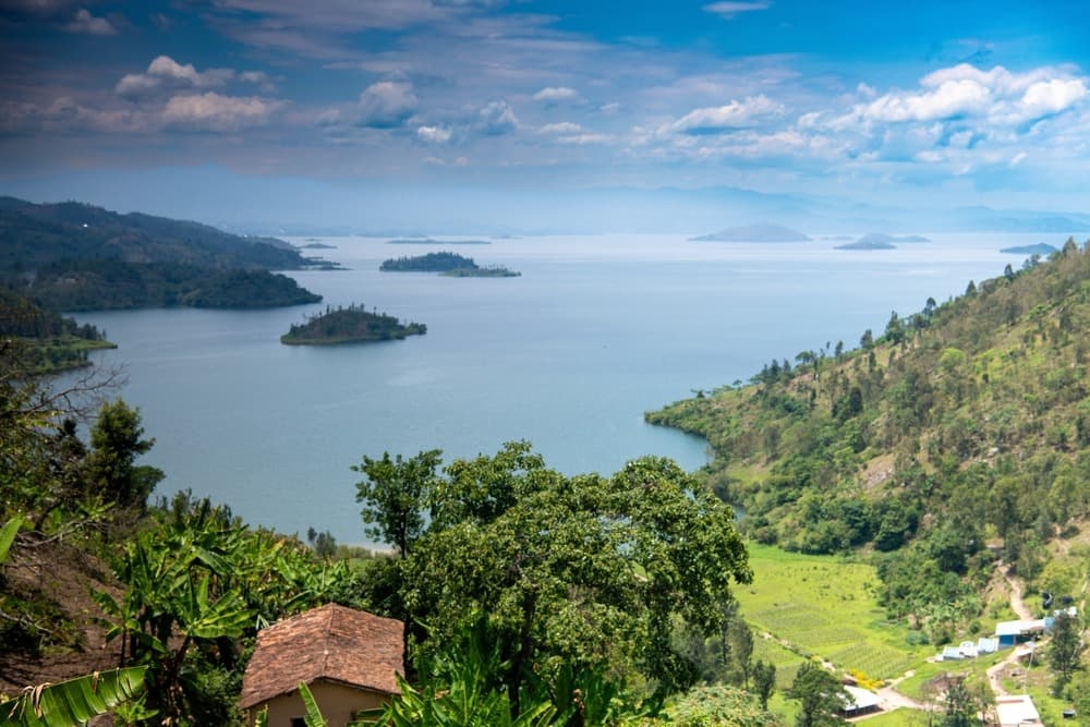
The coastline is carved into peninsulas, deep bays and chains of islands. Off Karongi, Napoleon Island owes its name to the bicorne silhouette its relief creates, and Bat Island is home to a colony of fruit bats that can be seen taking flight at dusk. Further south, the Amahoro archipelago and the islands of Idjwi (on the Congolese side) close the horizon. The landscape is ever-present: hills plunge directly into the water, terraced with banana, coffee and tea plantations toward the interior.
The local economy revolves around fishing and agriculture. On the water, triple-outrigger canoes (three hulls linked by poles) venture out at twilight. The fishermen sing while paddling, a practice inherited from the Bakiga people and the Banyabungo, to synchronize their strokes. They hunt for sambaza, small fish similar to sardines, found fried in every coastal eatery with a plate of plantains. Coffee grown on the slopes of Kinunu and Nyamasheke is washed in stations like Bumbogo, and several producers open their doors for roasting visits.
The region also carries heavy memories. Karongi was one of the epicenters of the 1994 genocide, and the memorial churches of Bisesero and Nyange recall this history. We systematically approach these sites with travelers who wish to, but never imposing: the lake lives today in a peaceful rhythm, marked by Kibuye's Friday markets and Sunday processions in Catholic parishes.
The Congo-Nile Trail connects Rubavu to Rusizi over 227 km, following the ridge line that separates the watersheds of the two great rivers. We offer it in sections: by bike (3 to 5 days) or by kayak along the coast, with nights in family homestays in Kinunu, Cyimbiri or Bumba. Hikers often prefer the short stretches between Kinunu and Musasa, which cross through coffee plantations and offer views of Napoleon and Amahoro islands.
Karongi remains our preferred stop for those seeking tranquility. Lodges there remain few in number (Cormoran Lodge, Moriah Hill, Bethanie), sunsets last nearly an hour over the clear horizon of the islands, and you can rent a motorized pirogue to dine on a private island. Rubavu, more lively, suits those combining the lake with Volcanoes Park, 1h30 away by road. Rusizi, more remote, fits into circuits extending toward Nyungwe.
To discover
Sunset from Karongi. Hills plunge into the water facing Napoleon and Amahoro islands. The sun descends slowly behind the silhouette of the Congolese Kivu, and fishing pirogues begin to venture out in triple formation.
Congo-Nile Trail by bike. Three to five days of trail between Rubavu and Kibuye, through Kinunu's coffee plantations and perched villages. Nights in family homestays and stops at coffee washing stations.
Fishermen's song at dusk. Outing in an outrigger pirogue around 5:30 p.m., from Kibuye harbor. Crews pace their paddle strokes to traditional song, heading toward sambaza fishing grounds.
Bat Island. Small island off Karongi that shelters several thousand fruit bats. At sunset, they take flight in a compact cloud toward the fig trees on shore.
Bushyuhe hot springs. On the northern shore near Rubavu, these springs emerge at over 70°C, evidence of rift volcanic activity. Villagers cook eggs there and dip banana leaves for cooking.
When to visit
Lake Kivu can be visited year-round, but two windows are far more comfortable. The long dry season, from June to mid-September, offers days of 24-26°C, cool nights of 15-17°C and clear skies ideal for swimming and water activities. The short dry season, from mid-December to February, is equally favorable, with slightly warmer temperatures. We avoid scheduling kayaking outings or long stretches of the Congo-Nile Trail between mid-March and mid-May: this is the height of the rainy season, with daily afternoon thunderstorms that can make clay paths impassable.
The 1,460 m altitude moderates the tropical climate: it is never oppressive, but evenings can be surprising. We recommend a light fleece even in the dry season. Lake water remains constant around 23-25°C year-round, allowing continuous swimming.
Practical advice
We recommend a minimum of 2 nights on Kivu to enjoy a full day on the water, and 3 to 4 nights if you wish to include a portion of the Congo-Nile Trail or visit multiple sections of coastline. Access is by road from Kigali: 3h30 to Rubavu (via Musanze, which allows you to combine with Volcanoes Park), 3h to Karongi via the direct route through Muhanga, and 5h to Rusizi. No domestic flights serve the region.
Kivu naturally combines with Volcanoes and the North via Rubavu, or with Nyungwe via Rusizi. It is the ideal decompression stop after gorilla trekking or the Nyungwe canopy walk. The region suits families (safe swimming, lodges with pools), contemplatives who settle in Karongi for a few days of reading facing the water, and active travelers drawn to biking or kayaking. Comfort levels range from intimate lodges (Cormoran in Karongi, Lake Kivu Serena in Rubavu) to family homestays along the Congo-Nile Trail.